Nobody likes a flood. As this summer’s historic floods demonstrated, some stay longer and rise higher than others. But eventually the water exits, cleanup ensues, lessons are learned and life finds routine again.
Well, at least for “normal” floods. In three separate but topographically similar regions in the Ninth District, high water forgot the part about making an exit, which leaves the rest of that list in limbo as well.
The issue concerns so-called terminal or closed-basin lakes, which have no natural outlet for high water to escape. These regions are essentially big bathtubs with no drain, and they’ve been bogged down in a wet cycle for years, with water rising … slowly … for the better part of two tortuous decades.
But that description doesn’t do justice to the problem—it sounds like the flood version of watching paint dry. Basin flooding is different; in some ways, “flood” itself is a misnomer because it implies something temporary. This is more like a slow-motion takeover by the Aqua Blob.
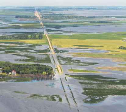
A road to nowhere dry: This road is one of many in the Devils Lake region that has become impassible, creating serious access problems for rural homes and farmsteads.
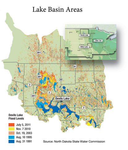
North Dakota, South Dakota and Minnesota each have a closed basin of differing size experiencing some degree of flooding. The Devils Lake basin in northeastern North Dakota is the granddaddy of the three; satellite imagery suggests that the basin has seen more than 600 square miles of terra firma swallowed since the early 1990s by its namesake lake and countless other lakes and potholes, according to the state Water Commission.
But similar basin flooding is also occurring in northeastern South Dakota and west-central Minnesota. Each region has different hydrological features, circumstances and consequences, but each faces a simple truth: Water is rising and is likely to keep rising for the foreseeable future. With no outlet, it will continue to invade homes, drown farmland and erode government budgets. While seemingly straightforward solutions are available, a variety of environmental and political obstacles stand in the way, which means there is no relief in sight for any of these regions.
Let’s start at the bottom
Because water always finds the lowest point, each of these closed basins has a “water-zero” lake.
Devils Lake, for example, serves as the bottom lake of a much larger waterlogged basin. Since the early 1990s, Devils Lake has risen from 1,422 feet above sea level (asl) to 1,454 feet this past summer and now covers about 190,000 acres. But it is far from the only bloated body of water in the basin. Figures from the Water Commission found that since 1991, some 450,000 acres throughout the basin had become submerged by this year. More than one in five acres in the basin is now underwater, according to satellite imagery; in 1991, it was just 3 percent.
From a long-term perspective, the rise is not unusual. Hydrology studies of the Devils Lake basin suggest that basin water levels fluctuate 20 to 40 feet every couple of hundred years. As recently as 1940, Devils Lake was just a shade over 1,400 feet asl, about 50 feet lower than today’s levels, and described by the U.S. Geological Survey (USGS) as a “shallow, brackish body of water” with a surface area of less than 7,000 acres. Past research by the agency said that “a rising or declining water level seems to be a more normal condition for Devils Lake than a stable water level.”
In the glacial lakes region of northeastern South Dakota, the lowest spot is Bitter Lake. In 30 years, the lake has gone “from 1,500 acres and about six inches deep to 20,000 acres and 30 feet deep,” said Wes Williams, director of emergency management in Day County, S.D. He said the eastern one-third of his county has become a “mini Devils Lake,” and among four or five other counties in that part of the state, “a lot of them will tell you the same story. The whole corner of northeastern South Dakota is having the same problem.”
Two decades ago, Bitter Lake was more than a mile from Waubay, a small community of about 525 that bills itself as the heart of the glacial lakes region. It has earned that reputation, because today Bitter Lake laps at the town’s southern border, while Blue Dog Lake borders to the north and Little Rush Lake to the west.
Studies of sedimentation and other methods have shown that the peak water elevation in Bitter Lake over the past 10,000 years is 1,803 feet asl. This summer it was mere inches below that level and three feet above its previous modern-day high of 1,800 feet asl. Water will eventually flow out of Bitter Lake if it ever hits 1,811 feet, but if that happens, half of Day County will be submerged, and “Waubay will probably be a ghost town,” said Williams.
In Minnesota, Otter Tail County and three counties to its west are seeing water levels about six to eight feet higher than normal, according to Terry Lejcher, a retired hydrologist for the Department of Natural Resources. Though flooding there is not on the same scale as the closed basins in the Dakotas, water nonetheless threatens about 300 homes in the area, most of them on Little McDonald Lake and, coincidentally, another aptly named Devils Lake.
The floods in each region stem from two simple factors: high precipitation for an extended number of years and lack of a natural outlet for that water to exit. According to precipitation records and local sources, all three regions have witnessed above-average precipitation every year, save for three or four, since the early 1990s. In the Devils Lake basin, average annual precipitation has been three inches higher over this period compared with the previous 80 years.
Without a natural outlet, the only way for water to exit these basins is through evaporation (or man-made solutions, which are very controversial and discussed later). But as water levels rise from higher precipitation, lakes hold proportionately more water and take longer to warm up, thus lowering evaporation rates. These basins have also been seeing heavier fall and winter precipitation, when there is little opportunity for evaporation.
Water torture
An outsider might think a cold swim is a small price to pay for bigger lakes and more water recreation. That attitude will get you a quick offer from locals to go jump in one of their lakes, because the Aqua Blob has been a slow wrecking crew.
In the northeastern corner of South Dakota, no official counts have been tallied at the county level. About 50 homes are flooded or inaccessible in or near Waubay, according to Williams. That doesn’t sound like much, but the whole county has fewer than 6,000 people.
“We’re small, so this is our Katrina,” said Williams, in Day County. “The last 10 years have been a bugger.”
To the north, the impact of the rising water is even more obvious in the Devils Lake region. Through 2009, more than 600 structures, including 450 residences, have been affected by rising water, according to the state’s 2010 technical report; some have been destroyed, others salvaged in part or relocated thanks to federal flood mitigation efforts. Over the past two years, the lake has also risen 4 feet, affecting an unknown number of additional structures.
The high water has drowned any notion of business as usual. Power companies have had to move distribution to higher ground for safety and reliability reasons. The operations of railroads Amtrak and BNSF have been affected because of weakened track running through the region. In the city of Devils Lake, there is nonstop traffic and dust from heavy trucks and other equipment working to raise major roads and keep them open; many smaller local roads have been sacrificed to the lake, creating much longer, out-of-the-way drives to nearby communities.
But from an economic standpoint, agriculture has borne the brunt of flood costs—a particularly harsh blow because farming is the economic mainstay of the affected areas. In the Waubay and Devils Lake regions, virtually every acre inundated by rising water was once cropland or pasture. Now the only thing grown on that land is frustration, plus some fish.
“Economically, it’s killing our towns and farmers,” Williams said. Given strong commodity prices and rising yields, that land is like sunken treasure because farm income supports many other local businesses “from the seed guy to the repair guy to the [farm implement] sales guy,” Williams said, adding that farmers also continue to pay $7 an acre in taxes.
An estimated (and possibly conservative) 250,000 acres in agricultural land—worth hundreds of millions when dry, and generating tens of millions in revenue annually—is underwater in Devils Lake. In some places, farms that were literally five, even 10, miles from water are now submerged.
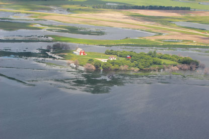
This farmstead in the Devils Lake region is representative of the flood challenges facing facrmers in closed basins.
A significant amount of other tillable land has gone unplanted because of impassable access roads. Al Freidig, a local real estate broker and head of the Devils Lake Chamber of Commerce, said his brother normally farms 4,200 acres in the area. Last year, he managed to plant only 2,900—desite the fact that just 66 acres are underwater. Access is destroyed by the water, Freidig said. “You can’t get to the acres.”
Farmers even lose official ownership of their own land, because the state holds jurisdiction on land that is underwater. Landowners can retain title to submerged land if it ever returns from the depths, but only if they continue to pay property taxes. Ramsey County (in North Dakota) has helped farmers out by reclassifying submerged land as wasteland, at a tax rate of $35 per quarter section (160 acres)—a 95 percent reduction in the tax rate, but still a considerable price for the mere hope of reclaiming land that once was yours.
Farmers with flooded land qualify for so-called prevented planting payments from their crop insurance policies. But those provisions expire four years after inundation (before a recent extension, it was three years), leaving farmers with few options afterward.
The economy in the city of Devils Lake has fared reasonably well, at least by some measures. Lakes tend to attract people, particularly if those lakes have fish in them. Tourism has grown in the region, evident in rising sales and room tax collections. Constant flood mitigation projects and road reconstruction have also buoyed the local economy.
But people are concerned about the future. “Our economy here has been artificially stimulated because of construction,” said Rick LaFleur, a local resident and operator of I.F. LaFleur & Sons, a provider of coin-operated amusement equipment. He added that when—or if—construction comes to an end, “they won’t turn in the key and leave tomorrow,” but the local economy will have to find its own legs.
LaFleur joked that “nowhere else do you create new lakefront property like Devils Lake.” But while outsiders are drawn to the water, locals fear it, their uncertainty evident by the fact that no one is willing to build on it anymore. Despite being a world-class walleye fishery and host to numerous tournaments, Devils Lake has seen only one resort built on it in recent years—and that one had to be moved to higher ground. In place of resorts, farmers have put in campgrounds for RVs and other vacationers, for which investment is much smaller and placement more portable.
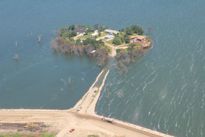
These island houses lie just south of Devils Lake, and just outside a levy (at the bottom of the picture) designed to protect the city from further lake encroachment.
While people elsewhere clamor for a place on a lake, locals are heading in the opposite direction, hoping the lake doesn’t follow them. According to several sources, people who ordinarily would be interested in buying or building a home are waiting because conditions are so unpredictable. LaFleur, for example, built on what he believed to be high ground in the late 1990s, when the lake was 10 to 12 feet lower. This summer, he agreed to a buyout from the city—his home subsequently and purposefully burned to the ground to make way for an improved dike to better protect the city from future lake encroachments.
High water bills
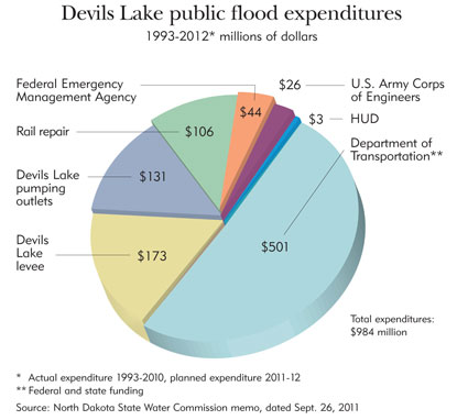
The encroaching water is also burning through government budgets. A September memo from the North Dakota Water Commission outlined nearly $1 billion in public costs to repair infrastructure and mitigate future flood damage, including several major projects planned for 2012 (see chart).
The price tag has grown so large in part because of a piecemeal approach to mitigation. Devils Lake City Engineer Michael Grafsgaard said that the standard operating procedure by federal and state officials for the past two decades “has been incremental infrastructure protection as required.” That has meant protecting the region and its assets for the short term on the assumption that the wet cycle would reverse and no further work would be needed.
That approach has been both unsuccessful and costly, particularly for the federal government. For example, repeatedly enlarging a major Devils Lake levee between 1996 and 2009 has cost $60 million, funded mostly by federal and state entities, according to the state Water Commission. With the lake reaching record high levels each of the past two years, the U.S. Army Corps of Engineers finally decided to raise the levee above the natural spillover level (1,458 feet asl) at a cost of $113 million, 75 percent of it coming from federal agencies.
Governments have taken a similar approach to fixing roads. When Devils Lake started rising, the state Department of Transportation set out to raise all state highways in the region to 1,440 feet, a level some 15 feet short in hindsight. From 1994 to 2005, state DOT figures show that $179 million was spent on flood-related road improvements around Devils Lake. More than 80 percent of the cost was picked up by the federal government, while the state paid 13 percent and the county took on the remainder. But as water has kept rising, area roads have required more than $300 million in additional spending to keep them above water.
There is virtually no end to the public assets and lives affected by water. A 1999 estimate by the U.S. Census Bureau said there were 110 people in Churchs Ferry, N.D., located on Lake Irvine north of the city of Devils Lake. Rising water levels have forced people out, and the 2010 census counted just 12 people. City leaders have broached and rejected the idea of dissolution.
Minnewaukan, a small community on the western end of Devils Lake, has watched water slowly encroach on local homes and businesses. In order to keep the city’s lone school open another year, the Army Corps built a $1.2 million temporary levee, while a new $10.5 million facility is under construction a few miles away on higher ground. Meanwhile, the city’s population has dropped from about 320 a few years ago to less than 200.
Northeastern South Dakota is dealing with similar problems, albeit smaller in scale. Half of the county-owned roads in Day County are underwater or inaccessible, said Williams, director of emergency management. He estimated that 70 percent of those roads will be donated to the lake until it decides to give them back permanently. In two townships, only nine of 36 miles of town road are drivable. “I can show you roads that were raised two or three times, and they are still underwater,” Williams said. Nearby counties are in a similar predicament.
In Waubay, sales tax collections fell last year by more than 12 percent, and they are expected to drop again this year, according to local reports. The town’s population has fallen from 662 in 2000 to 525 today; the school population has dropped more significantly, from 220 students five years ago to 160 this year. The removal of cabins from lakes has lowered property values and tax revenues, making for very tight budgets. “I’ve had trouble asking to buy a pen or pencil,” Williams said. County workers also took a wage freeze this year.
Watered-down solutions
While you might think the solution to a closed basin is rather simple—dig an outlet ditch, silly—the reality is considerably more complicated, for both environmental and political reasons.
Devils Lake city officials have long been arguing for a gated drainage ditch—or “gravity outlet” in engineering-speak—from Stump Lake, which connects to the eastern end of Devils Lake via coulees and offers the best access to the Sheyenne River, which eventually flows to the Red River. Such a project was proposed back in 1999 and would have cost just $2.2 million. It would have allowed for the controlled release of water from the basin. Over time, natural erosion would likely deepen the outlet, letting Devils Lake drop by an estimated 8 to 10 feet. The cost of this option today is estimated at $10 million.
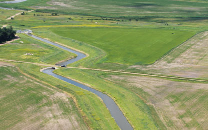
This narrow channel is the first of two man-made efforts to drain water from Devils Lake. At full capacity, the ditch drains about 250 cubic feet of water per second, but the water has to be pumped uphill at significant cost to reach the outlet. A second outlet, which also requires pumping, was approved last year and is expected to be operational this year.
What seems like a simple and affordable option is anything but. Communities downstream on the Sheyenne worry about discharges that are high in sulfates, which have become concentrated expressly because of the closed nature of the basin. Water can leave the basin only through evaporation, and when water evaporates, it leaves behind sulfates—just like on the rim of your kid’s fishbowl. Westerly winds further concentrate sulfates at the eastern end of the lake, where a gravity outlet would be most sensible.
Although the actual health impacts are fiercely debated, concern over sulfates has given environmentalists and downstream stakeholders—including Canada, where the water eventually flows—traction to block this option. Two downstream groups have retained a Minneapolis law firm to represent them.
Communities on the Sheyenne also worry about increased flows in the river, which is probably more aptly described as a stream most of the time. Valley City, N.D., located more than 100 miles downstream of Devils Lake, has objected to the gravity outlet out of fear that it could potentially swamp the city if a torrent were allowed to flow through to the Sheyenne. Residents are jittery after near-record flooding occurred in 2009 and again this spring—without Devils Lake discharges into the Sheyenne.
As a stopgap measure in 2005, the state installed a pumping station to move 250 cubic feet of water per second (cfs) into the Sheyenne River. The project cost $60 million, but operating costs are huge. Out of deference to the environment, pumping stations were placed on the western end of the lake (where sulfate levels are lower), requiring water to be pumped 200 feet uphill through three lift stations to reach the Sheyenne. That small, artificial outlet generates a monthly power bill of $300,000, paid by the state. Said one Devils Lake source, “That [power] meter spins pretty fast.”
With rapidly rising water levels—the lake has risen 4 feet in the past two years—it’s widely agreed that something more must be done, but there is little agreement on what. The state is in the process of installing a 6-mile-long pipe to pump an additional 350 cfs of water from the western end of the lake into the nearby Tolna Coulee, which would drain into the Sheyenne River. This project is slated to become operational sometime this year at a cost of about $90 million—which doesn’t include considerable operating costs. The state also plans a $10 million control structure on the Tolna Coulee to guard against natural uncontrolled overflow. Local officials have objected because the structure would prevent Devils Lake from dropping below current levels unless precipitation patterns change.
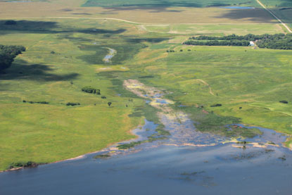
This nondescript piece of land is the Tolna Coulee, located on the southwest corner of Stump Lake, which is connected to Devils Lake. Water would begin to flow into the Tolna Coulee if Devils Lake reached 1,458 feet above sea level - just four feet more than levels reached last year.
And even when the additional pump outlet is operational, it isn’t expected to keep the lake from rising further should the wet cycle continue; rather, it will merely slow the lake’s rise. Eventually, if water rises another 4 feet to 1,458 feet asl, the Devils Lake bathtub will be officially full, and water will spill out and flow toward the Sheyenne River. Hydrology research suggests that this happened roughly a thousand years ago. And if it happens again, the spillover won’t likely be a trickle.
The Sheyenne has an in-channel flow capacity of only about 600 cfs, and it regularly overtops its banks with the spring melt. Should Devils Lake rise above 1,458 feet asl, it would cover more than 250,000 acres (not including other lakes in the basin), and overflow would be the equivalent of pouring a five-gallon bucket of water through a straw.
When Valley City flooded in 2009, and again in 2011, the Sheyenne peaked briefly at 7,000 cfs. Flood stage on the Sheyenne at West Fargo is just 2,300 cfs. Estimates for an uncontrolled spill vary, but range from several hundred to several thousand cfs. Worst-case scenarios predict a virtual deluge downstream.
Downstream communities block outlet options for their own safety, hoping that Devils Lake does not continue to rise; yet they do so at their own peril if the region’s wet cycle persists. Studies to date have been persistently optimistic about the low risk of higher lake levels. As recently as 2008, a study by the USGS suggested that there was only a 1 percent chance that the lake would hit 1,454.6 feet in the next 10 years; it came within inches of that level last summer. A September study by the USGS of the new outlet estimated a 10 percent chance of reaching 1,458 feet by 2015 and a 2 percent chance of hitting 1,460 feet.
Many locals believe those figures grossly understate the threat. “The [flood estimates] are so totally flawed,” said LaFleur, of I.F. LaFleur & Sons. For the past 15 years, “they’ve been saying there’s a 1 percent chance of the water rising, and it’s done it year after year after year.”
Mother (Nature) knows best
That’s the fear in west-central Minnesota, where water levels have created some inconvenience, but have not created real hardship like that seen across the state border. Rick West, engineer for Otter Tail County, said he recently had to drive 32 miles to reach a destination eight miles away because so many township roads were closed. To date, the county has spent upward of $5 million on a handful of water-pumping projects to keep county roads above water.
West is hopeful that water levels will fall—a dry autumn was very helpful, he noted—but aware and wary of what might lie ahead because storage for additional water is gone. “If trends in rainfall and snowpack continue over the next five years, it’s going to be serious,” West said. “There’s no doubt about it.”
In the Waubay region, not much has happened in terms of big mitigation projects. In 1999, the Army Corps of Engineers suggested annual pumping and drainage options for Bitter Lake, but the costs were locally prohibitive. Williams said the state has been trying to help where it can in the region, mostly because “we’ve been screaming like a dry bearing on a combine.”
But he also pointed out that win-win solutions are scarce. “You don’t fight Mother Nature … and you can’t wish for a dry four or five years,” because most weather experts believe the region will remain in a wet cycle for some time. Locals have their own home-cooked solutions, he said, but often ignore numerous obstacles, including downstream landowners whose property could be inundated, at least on a seasonal basis. “People downstream don’t want your problem,” Williams said, “You don’t want me draining my pond through your yard.”
He said many people in the region—himself included—are “next-year people,” optimistic to a fault that things are going to get better.
But just in case, Williams says he follows the Devils Lake situation in hopes of learning some lessons before they become the hard sort. For example, he said, “we’re trying to get away from repetitive costs” like those seen to the north. Despite constant efforts to stay just ahead of water levels in Devils Lake, “all they’ve gained is a fishery, and fishing don’t put corn in the bins, or beans on the road.”
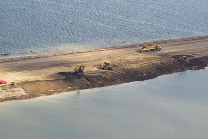
Hundreds of millions of dollars have been spent raising highways like this one in the Devils Lake region, sometimes multiple times as water levels continue to rise..
Ron Wirtz is a Minneapolis Fed regional outreach director. Ron tracks current business conditions, with a focus on employment and wages, construction, real estate, consumer spending, and tourism. In this role, he networks with businesses in the Bank’s six-state region and gives frequent speeches on economic conditions. Follow him on Twitter @RonWirtz.


